Below are the new features:
Field Data
Share time-dependent transformation parameters with Trimble Access. The JXL importer and exporter in TBC have been updated to include time-dependent transformation data to ensure transformation is performed using the same parameters in both TBC and Trimble Access, regardless of the version of the Coordinate System Database being used with each.
GIS
ArcGIS users can use the GIS Connection Manager command to connect to a file geodatabase, and enterprise geodatabase to download schemas and upload features to ArcMap or ArcPro using the new and updated ArcGIS provider.


IFC and TRB
IFC support in TBC has been enhanced to import and export Trimble TrimBim (TRB/.trb) files containing BIM/IFC data that can display varying types of geometry in the graphic views, including meshes and linework. View the IFC hierarchy of BIM objects nested beneath the BIM Data parent node in the Project Explorer. And, view read-only BIM entity properties. Export all or some of the BIM entities in your project in a single TRB (.trb) file enabling you to export entities from multiple IFC projects that have been imported into your TBC project in a single export file.

Point Clouds
Extract Cross-Sections from a Point Cloud
Use the new Extract Cross-Sections from a Point Cloud command to extract open or closed 3D cross-section line segments from a point cloud based on two scan points, reference lines or an alignment.

Define Complex Profiles for Curb and Gutter Line Extraction
The Extract Line Feature command, which enables you to create linestrings from curb and gutter features displayed in a point cloud, has been enhanced to enable you to select up to ten nodes (four was the previous limit) to define more complex feature profiles for line extraction, such as road barriers, and curb and gutter with sidewalks.

Auto-Select Overhead Utility Lines for Line Extraction
The Extract Line Feature command, which enables you to create linestrings from overhead utility line features displayed in a point cloud, has been enhanced to auto-select lines that are parallel and adjacent to a selected line within the distance you specify. This can be very helpful if you are extracting many lines as might be the case, for example, with large power towers.

Export Trimble X7 Data to Trimble TMX
Use the new X7 to TMX exporter to export Trimble X7 laser scanner data to the Trimble TMX-2050 Display System, which features a large high-definition touch screen with sharp visuals and a choice of FmX® Plus or Precision-IQ™ display applications to suit your specific farm practices.

Aerial Photogrammetry
You can now import geo-referenced ECW (Enhanced Compression Wavelet) aerial image files with embedded map projection information to use as background images in TBC. ECW technology provides exceptional compression, capable of reducing very large files to five percent of their original size, while retaining the image’s full visual quality. Because of the small file size provided by the ECW format, files can easily be stored, transferred, and displayed, even on small devices. ECW-formatted images are supported in all TBC graphic views, including dynaviews and plotboxes, and can be used as a background map. Use the Options command to specify whether to copy ECW files into the project folder on import, or reference them at their current location.

Tunnels
The TBC Tunneling module introduces key updates that add new functionality to support unique workflows such as tunnel convergence reporting and improve data visualization by incorporating as-built and monitoring data in the Tunnel View and enhancing the Tunnel Inspection View.
Monitor Tunnel Convergence
Use the new Assign Tunnel Convergence Points command to monitor tunnel convergence points by storing and comparing coordinates for tunnel points that have been measured in the field over a period of time. The cumulative data tracks movement over time resulting from tunnel deformation. Movement vectors can be viewed in graphic and tabular views using the Convergence Points tab in the Tunnel View or in the customizable Tunnel Convergence Report. Displacements generated by this analysis are reported relative to the tunnel design alignment in terms of station, offset, and elevation.
Note - The TBC Monitoring module is required to utilize these new commands.

Specify Label Interval in Tunnel Inspection Cross-Section View
Use Project Settings to specify the distance interval at which labels are displayed in the Tunnel Inspection Cross-Section View. This setting is useful when you want to maintain a high level of density in the Inspection Plan View while still being able to view readable labels in the Cross-Section View and the resulting Inspection Report. This is commonly used for construction verification and shotcrete layer thickness inspection.

View As-built Points in the Tunnel View
Use the Tunnel View command to quickly view a graphical and tabular comparison between assigned as-built points and a tunnel design to determine overbreak and underbreak information for construction verification and quality control, similar to the information displayed in the Tunnel As-Built Report.

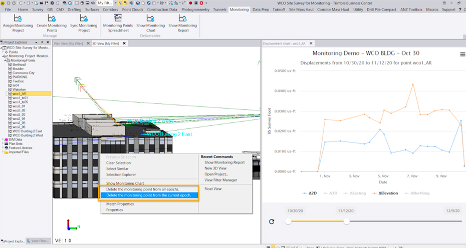
Monitoring
The TBC Monitoring module has been enhanced to provide additional flexibility when editing monitoring data with delete epoch options and reducing time to generate monitoring deliverables by automating the Monitoring Project synchronization.
Point Monitoring Enhancements
The point monitoring feature in TBC has been enhanced as follows: After selecting points to monitor, the automatic synchronization process begins immediately (no need to first run the Sync Monitoring command as before). This eliminates the need for an additional command when adding new epochs to a monitoring project. You can select any monitoring point in the Project Explorer and select to delete it from the current epoch or from all epochs. This provides additional flexibility for managing monitoring projects in TBC.

Licensing
To better align features with targeted workflows and customer needs, the following licensing changes have been made for this release of TBC:
- A new entry-level TBC Starter subscription edition has been added for GNSS, total station, and digital level-based workflows as well as basic machine and field data file preparations.
- The Sample Point Cloud Region and Sample Region by Intensity commands are now included with the Surface Modeling Edition perpetual license and available in all subscription license editions except the new entry-level TBC Starter.
Thanks for checking out the the new 5.50 version of Trimble Business Center, happy surveying!